| |
| |
| Photograph
October 2005: Courtesy of Phil Edwards |
|
| |
Wichita,
Kansas
-- 7300 (7600 & 7270) E. Kellogg Ave |
| |
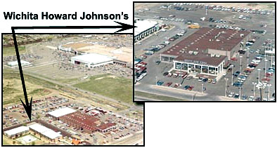
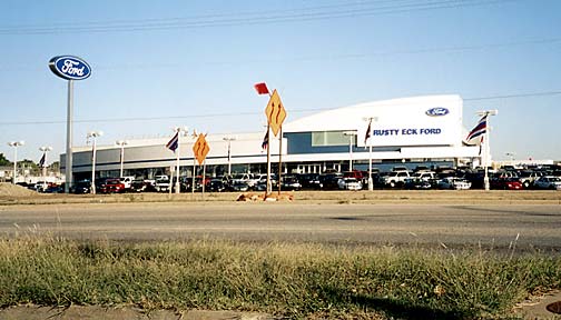
The
second of the Sunflower State's Howard Johnson's complexes, Wichita
opened in August of 1964. Featuring 78 rooms in its classic layout,
the Motor Lodge retained the Howard Johnson's name until 1987. Rusty
Eck Ford moved adjacent to the HoJo's in 1970, and eventually came
to own the entire property. A realignment of Kellogg Ave. (U.S.
54) necessitated removal of buildings fronting the highway and the
vintage HoJo's was demolished to make way for the dealership's new
showroom.
Below:
A tiny but tantalizing low resolution aerial shot shows the Howard
Johnson's adjacent to Rusty
Eck Ford during the 1970s--you can just make out the property's
"L" configuration as well as the Orange Roof of the signature
A-frame Gate Lodge. Note too that the image shows Town
East Square Mall's close proximity to the Motor Lodge and Restaurant
complex. |
|
| |
|
| |
| |
|
| lexana |
| |
|
| |
Kansas
City-Southwest-Lexana, Kansas --
12381 W. 95th St.
|
| |
Nothing
remains of the Lexana complex that opened in the spring of 1972
and lasted until 1992 as a Howard Johnson's. The Motor Lodge had
featured 112 guest rooms, lighted tennis courts, and was near Oak
Park Mall. |
|
| |
| Photographs
October 2005: Courtesy of Phil Edwards |
|
| |
| |
|
| |
| |
|
| turnpike |
| |
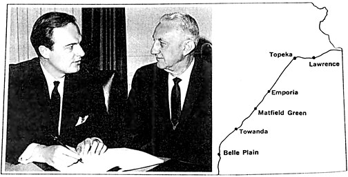
| Howard
Johnson's Landmark: May 1968, page 1 |
|
| |
| Kansas
Turnpike |
| |
| #1
Belle Plaine |
| #2
Towanda |
| #3
Matfield Green |
| #4
Emporia |
| #5
Topeka |
| #6
Lawrence |
|
Above:
When president Howard B Johnson ... and L. W. Newcomer,
chief engineer/manager of the Kansas Turnpike Authority, signed
a 10-year lease, we welcomed 148 new employees to our family
and the company began operating six dining rooms on the Turnpike.
The 236-mile pike opened in 1956, carried over 8.5 million
vehicles last year and has the country's highest speed limit
-- 80 mph. Our new dining facilities, accessible to traffic
in both directions, are located at the service areas shown
above. These six new units join our restaurants in Topeka
and Kansas City for a total of eight locations in the Sunflower
State |
|
|
| |
| Postcards
circa 1950s: Courtesy of Dan Donahue |
| |
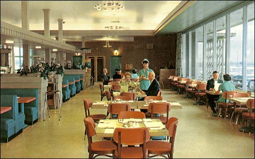
Above:
Dining room of a typical Olympic House Restaurant in one of the
Kansas Turnpike's service plazas.
Opened
in 1956, the Kansas Turnpike offered motorists six service plazas
with dining facilities and gift shops operated by the Olympic
House of Kansas. Olympic House relinquished its contract and Union
News of New York became the concessionaire by the middle 1960s.
In March of 1968 after it was determined that Union News was ineligible
to continue its contract, the Kansas Turnpike Authority sought
a new operator and received bids from Interstate Host, Howard
Johnson's, Fred Harvey, and Gladieux Corp. With little debate,
the Authority quickly chose Howard Johnson's which had already
firmly established itself as the premier provider of toll road
food service. The Company agreed to spend $400k remodeling the
turnpike's facilities, and at the time that Howard Johnson's began
operating the Turnpike's restaurants the Company counted 82 units
on toll highways across the United States. In 1972 the six restaurants
were converted into cafeteria-style eateries in order to speed
food delivery to travelers. It is believed that the units were
operated by the Company until its dissection in 1985.
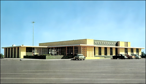
Below:
Exterior of a Kansas Turnpike service plaza while it housed an
Olympic House Restaurant.
|
|
| |
|
| |
| |
| |